Winter has finally arrive in the mid-east. For a few days at least. The forecasted storm (which didn't pan out the way the weather peeps thought in our area) canceled our trip to a beer fest in Asheville. We still almost drove up in spite of that, but beer is so versatile it can be consumed practically anywhere. So here we stayed and watched a ton of streaming TV.
Now that I've actually made it out of pajamas (earlier today - I'm back in them now) I figured it was time to be somewhat productive to prepare for hitting the real world tomorrow. Booo....
This past September, Blake and I went on a trip out west to visit some national parks; mainly the Grand Canyon. Our original intent was to backpack across - Rim to Rim. But obtaining a permit to be below the canyon overnight is near impossible for September. The ranger at the back country office was overly nice and gave me some great suggestions for alternative hikes. It was refreshing to talk with someone who you know gets paid peanuts, but actually loves the job they do.
So here's a list of the parks we visited and the trails we hiked. I could write for hours and hours about each of the magnificent places we visited. And we didn't even get to see it all.
Hike 1: Cape Final Hike, North Rim Grand Canyon - 2 miles one way
This hike was recommended by the camp ground ranger on duty the morning after we arrived. There were a few cars at the trailhead, but most of the hikers were on their way out since we started a little later in the morning. The trail is a mixture of gradual ascents and descents through a gorgeous meadow. It reminded me much of the pine savannas back east. Once you reach the end of the trail, you're greeted with wide sweeping views over the canyon and beyond. As with most vista points in the Grand Canyon, words cannot completely describe the overwhelming feeling of seeing these landscapes. But what was great about this hike is we were the only hikers out there for about 20 minutes. Another couple came hiking in, but there was so much room we were able to eat our packed lunches in silence. There was one campsite out there, and the ranger had told me it was an easy one to get a permit for.
 |
| Vista at Cape Final |
 |
| Vishnu Temple from Cape Final |
 |
| Ponderosa pine meadow |
Sunrise hike: Hike down the North Kaibab Trail to Coconino Overlook. The sun will rise behind you and cast its light on the canyon walls across from you. It's gorgeous. And quiet.
 |
| Sunrise at Coconino Overlook - North Kaibab Trail |
Hike 2: Rim Trail, South Rim Grand Canyon - about 12 miles one way
I know what you're thinking. How can a paved trail in one of the busiest national parks be even remotely good? I'll tell you why: because people are lazy. That's why. It's true this trail has more traffic on it near the parking areas and bus stops, but the majority of visitors will venture out a few hundred feet, take their pictures, and then hop in their cars or on the next bus for the next stop. In between can be anywhere from 1-3 miles of solitude. And it's flat. As a pancake. Which means you could hike the entire thing easily and see some of the best views of the park with just your pack in tow.
 |
| The South Rim has the best views but more people. Like this bozo. |
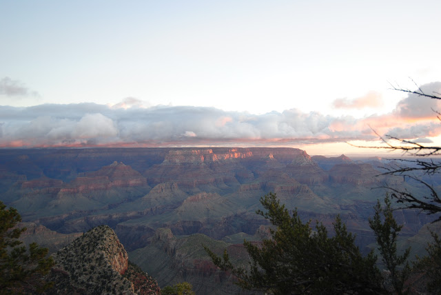
Sunrise hike: Because we try to be as alone as possible, we woke up extra early and drove 12 or so miles to Grandview Point for sunrise. There were already a few people there, but we all had the same intention - to enjoy a peaceful sunrise. I'm sure if you had more time to hike down the Grandview Trail before the sun peeked its head up you'd find more solitude.
 |
| Sunrise at Grandview Overlook |
Hike 3: Angel's Landing, Zion Natl Park, 5 miles one way
Do you hate heights? This trail is probably not for you. With our limited time in Zion we wanted to hit the main sections of the park. Our trip to the start of the Narrows hike the day before was nice, but flash flooding in the area kept us from going farther than that. Seven hikers would lose their lives the following night in a similar slot canyon within the park. We wanted to test our legs on Angel's Landing (once thought to be so tall, that only angels could land on its summit). As true Americans would say, "Challenge accepted." So they built a "trail" up to the top. And if the first part of the trail (usually paved - but a quad shredder) doesn't frighten you away, the realization that you are, in fact, NOT at the top when you think you are should. We used the chains bolted into the rock to scramble to a flat area. Once we caught our breath, our hearts sank. Slowly, your eyes follow the chains across a narrow rock path and then, even more slowly, up...up....up.... At the top you can barely see movement of other hikers. Yikes. Of course I wanted to go, but with the impending thunderstorm and lack of faith from Blake, we turned around. But not before I crossed the 4-ft wide (at most) rock path with the 1,000 foot drop on either side just to say, "I did it." I will conquer this trail next time I'm in Zion. I promise.
 |
| Angel's Landing Summit and the storm rolling down the canyon |
 |
| I walked across and took this photo looking back toward Blake |
 |
| The famous "Walter's Wiggles." A series of 21 switchbacks right before you reach the chains. This is about 30 minutes into your hike straight up the canyon. Kinda daunting. |
Hike 4: La Madre Spring (Hike 10), Red Rock Canyon, 3.3 miles one way
Red Rock Canyon is absolutely amazing, especially for being only 30 minutes outside of Vegas. This hike was listed in the trail guide as good for seeing wildlife since it ended at a natural spring. I'd been jonesing to see a big horn sheep since Zion where one had scrambled majestically up the canyon wall at the entrance. We started in the Willow Spring Picnic Area since we didn't have a high clearance vehicle. It was blazing hot, so the chance of seeing people was slim. The spring was nice, cool, and provided some shade. Enough that some passing hikers never knew we were sitting under a tree eating a snack when they passed. We sat quietly for 30 minutes, hoping to see something,
anything. No luck. As we walked back I was lamenting the fact that I never got to photograph a big horned...there he was. Looking down on us from his rock perch. Probably waiting for us to pass on so he could go get a drink. I held back a squeal as I foraged in my pack for my other lens. I had to sit on the trail to steady the shot. I have a lot of pictures of this guy. I was on cloud nine.
 |
| It was such a beautiful day |
 |
| Oasis in the desert |
 |
| My buddy! |
 |
| So majestic |
Hike 5: Cathedral Rock, Mt. Charleston (Spring Mountains), 1.5 miles one way
I walked into the Visitor Center with two goals: 1) get a national parks cancellation (which they don't have) and 2) get a good hike recommendation. My question to the woman behind the desk, "If you had 4 hours to hike any trail here, which one would you do."
Her answer, "Easy. Cathedral. As long as you have good hiking legs" And proceeded to give me directions.
We'd done nothing but hike since we woke up in the North Rim, but this trail was challenging. There were a few sets of people hiking, but mostly we had the trail to ourselves. Independently that is. Blake's trail legs were in full force, and he marched up the mountain. There were times I'd round a bend and see his pack quickly disappearing around the next. He'd wait for me to catch up and catch my breath - but I could never keep up with him. At one point, he came back for me because I had met a nice older gentleman who was showing me fossils. That was more my pace. The view from the top was breathtaking in itself. Being mid-September at high elevation (the highest I've ever hiked actually), some of the quaking aspens had started changing colors. The view of the other peaks behind us was gorgeous, but what really struck me was seeing the desert far beyond the valley we had driven into. From here, the transition between forest and desert seemed so abrupt, like it shouldn't even be here. It was a wild experience.
 |
| Looking out toward the desert from atop my cathedral |
 |
| Almost fall |
 |
| Imprints |
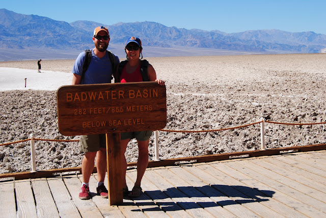
"Hike" 6: Badwater, Death Valley Natl Park, about 66 miles (so make sure you have gas and lots of water in case you break down)
When it's 103 degrees F in a place with zero shade (and your husband is allergic to the sun) the smartest thing to do is sit in a reliable vehicle with great AC. Nothing spectacular about that, eh? True - but I still have a suggestion about Death Valley (other than don't go when it's still super hot). Drive the entire length of Badwater. Most visitors drive to Badwater proper and hop out for their pics at the lowest point in North America. There is a trail we would have liked to hike out on here, and we will probably return to do it in say...October/November. But the best part is that once you turn right out of the parking lot, you lose 95% of the people. It's a gorgeous drive in an almost alien landscape.
 |
| Look, ma! We're low lives! |
 |
| My tootsies being low down and dirty |
 |
| Blake says, "It tastes like salt." |


