Sunday, January 24, 2016

Winter Warmer

Winter has finally arrive in the mid-east. For a few days at least. The forecasted storm (which didn't pan out the way the weather peeps thought in our area) canceled our trip to a beer fest in Asheville. We still almost drove up in spite of that, but beer is so versatile it can be consumed practically anywhere. So here we stayed and watched a ton of streaming TV.

Now that I've actually made it out of pajamas (earlier today - I'm back in them now) I figured it was time to be somewhat productive to prepare for hitting the real world tomorrow. Booo....

This past September, Blake and I went on a trip out west to visit some national parks; mainly the Grand Canyon. Our original intent was to backpack across - Rim to Rim. But obtaining a permit to be below the canyon overnight is near impossible for September. The ranger at the back country office was overly nice and gave me some great suggestions for alternative hikes. It was refreshing to talk with someone who you know gets paid peanuts, but actually loves the job they do.

So here's a list of the parks we visited and the trails we hiked. I could write for hours and hours about each of the magnificent places we visited. And we didn't even get to see it all.

Hike 1: Cape Final Hike, North Rim Grand Canyon - 2 miles one way
This hike was recommended by the camp ground ranger on duty the morning after we arrived. There were a few cars at the trailhead, but most of the hikers were on their way out since we started a little later in the morning. The trail is a mixture of gradual ascents and descents through a gorgeous meadow. It reminded me much of the pine savannas back east. Once you reach the end of the trail, you're greeted with wide sweeping views over the canyon and beyond. As with most vista points in the Grand Canyon, words cannot completely describe the overwhelming feeling of seeing these landscapes. But what was great about this hike is we were the only hikers out there for about 20 minutes. Another couple came hiking in, but there was so much room we were able to eat our packed lunches in silence. There was one campsite out there, and the ranger had told me it was an easy one to get a permit for.

Vista at Cape Final

Vishnu Temple from Cape Final

Ponderosa pine meadow
Sunrise hike: Hike down the North Kaibab Trail to Coconino Overlook. The sun will rise behind you and cast its light on the canyon walls across from you. It's gorgeous. And quiet.
Sunrise at Coconino Overlook - North Kaibab Trail

Hike 2: Rim Trail, South Rim Grand Canyon - about 12 miles one way
I know what you're thinking. How can a paved trail in one of the busiest national parks be even remotely good? I'll tell you why: because people are lazy. That's why. It's true this trail has more traffic on it near the parking areas and bus stops, but the majority of visitors will venture out a few hundred feet, take their pictures, and then hop in their cars or on the next bus for the next stop. In between can be anywhere from 1-3 miles of solitude. And it's flat. As a pancake. Which means you could hike the entire thing easily and see some of the best views of the park with just your pack in tow.
The South Rim has the best views but more people. Like this bozo.


Sunrise hike: Because we try to be as alone as possible, we woke up extra early and drove 12 or so miles to Grandview Point for sunrise. There were already a few people there, but we all had the same intention - to enjoy a peaceful sunrise. I'm sure if you had more time to hike down the Grandview Trail before the sun peeked its head up you'd find more solitude.
Sunrise at Grandview Overlook

Hike 3: Angel's Landing, Zion Natl Park, 5 miles one way
Do you hate heights? This trail is probably not for you. With our limited time in Zion we wanted to hit the main sections of the park. Our trip to the start of the Narrows hike the day before was nice, but flash flooding in the area kept us from going farther than that. Seven hikers would lose their lives the following night in a similar slot canyon within the park. We wanted to test our legs on Angel's Landing (once thought to be so tall, that only angels could land on its summit). As true Americans would say, "Challenge accepted." So they built a "trail" up to the top. And if the first part of the trail (usually paved - but a quad shredder) doesn't frighten you away, the realization that you are, in fact, NOT at the top when you think you are should. We used the chains bolted into the rock to scramble to a flat area. Once we caught our breath, our hearts sank. Slowly, your eyes follow the chains across a narrow rock path and then, even more slowly, up...up....up.... At the top you can barely see movement of other hikers. Yikes. Of course I wanted to go, but with the impending thunderstorm and lack of faith from Blake, we turned around. But not before I crossed the 4-ft wide (at most) rock path with the 1,000 foot drop on either side just to say, "I did it." I will conquer this trail next time I'm in Zion. I promise.
Angel's Landing Summit and the storm rolling down the canyon

I walked across and took this photo looking back toward Blake

The famous "Walter's Wiggles." A series of 21 switchbacks right before you reach the chains. This is about 30 minutes into your hike straight up the canyon. Kinda daunting.

Hike 4: La Madre Spring (Hike 10), Red Rock Canyon, 3.3 miles one way
Red Rock Canyon is absolutely amazing, especially for being only 30 minutes outside of Vegas. This hike was listed in the trail guide as good for seeing wildlife since it ended at a natural spring. I'd been jonesing to see a big horn sheep since Zion where one had scrambled majestically up the canyon wall at the entrance. We started in the Willow Spring Picnic Area since we didn't have a high clearance vehicle. It was blazing hot, so the chance of seeing people was slim. The spring was nice, cool, and provided some shade. Enough that some passing hikers never knew we were sitting under a tree eating a snack when they passed. We sat quietly for 30 minutes, hoping to see something, anything. No luck. As we walked back I was lamenting the fact that I never got to photograph a big horned...there he was. Looking down on us from his rock perch. Probably waiting for us to pass on so he could go get a drink. I held back a squeal as I foraged in my pack for my other lens. I had to sit on the trail to steady the shot. I have a lot of pictures of this guy. I was on cloud nine.

It was such a beautiful day

Oasis in the desert

My buddy!

So majestic

Hike 5: Cathedral Rock, Mt. Charleston (Spring Mountains), 1.5 miles one way
I walked into the Visitor Center with two goals: 1) get a national parks cancellation (which they don't have) and 2) get a good hike recommendation. My question to the woman behind the desk, "If you had 4 hours to hike any trail here, which one would you do."

Her answer, "Easy. Cathedral. As long as you have good hiking legs" And proceeded to give me directions.

We'd done nothing but hike since we woke up in the North Rim, but this trail was challenging. There were a few sets of people hiking, but mostly we had the trail to ourselves. Independently that is. Blake's trail legs were in full force, and he marched up the mountain. There were times I'd round a bend and see his pack quickly disappearing around the next. He'd wait for me to catch up and catch my breath - but I could never keep up with him. At one point, he came back for me because I had met a nice older gentleman who was showing me fossils. That was more my pace. The view from the top was breathtaking in itself. Being mid-September at high elevation (the highest I've ever hiked actually), some of the quaking aspens had started changing colors. The view of the other peaks behind us was gorgeous, but what really struck me was seeing the desert far beyond the valley we had driven into. From here, the transition between forest and desert seemed so abrupt, like it shouldn't even be here. It was a wild experience.
Looking out toward the desert from atop my cathedral

Almost fall

Imprints

"Hike" 6: Badwater, Death Valley Natl Park, about 66 miles (so make sure you have gas and lots of water in case you break down)
When it's 103 degrees F in a place with zero shade (and your husband is allergic to the sun) the smartest thing to do is sit in a reliable vehicle with great AC. Nothing spectacular about that, eh? True - but I still have a suggestion about Death Valley (other than don't go when it's still super hot). Drive the entire length of Badwater. Most visitors drive to Badwater proper and hop out for their pics at the lowest point in North America. There is a trail we would have liked to hike out on here, and we will probably return to do it in say...October/November. But the best part is that once you turn right out of the parking lot, you lose 95% of the people. It's a gorgeous drive in an almost alien landscape.
Look, ma! We're low lives!

My tootsies being low down and dirty

Blake says, "It tastes like salt."

Wednesday, October 21, 2015

Kimby Bikes

THE PEEPS!
 The last weekend in August saw me saddled up on my mountain bike supporting my best friend since kindergarten in her Bike MS ride along the Greenbrier River Trail in West Virginia. After 3 years of tests and suspicions, she was finally diagnosed with Multiple Sclerosis this past spring. I had already promised to raise money and ride long before her diagnosis. But knowing for sure she had MS made it a little more real. I wasn't just riding for my friends' reasons for donating to my ride, but I was riding for her: because it was meaningful to her and because she rides with MS.
1st rest stop. Me: Hey, this ain't so bad! (HAH)
The trail trek is reportedly 60 miles. But when you start at mile marker 14 and end at MM 80 that math doesn't compute. A check on Map My Ride confirms the trail trek is approximately 66 miles. But the route is well stocked with some nicely placed rest stops. And Blake and Mandy's aunt are able to SAG for us. Day 1 of the trek starts in Anthony, WV and ends in Cass.

It was a right eventful first day. Mandy's uncle hit the side of the tunnel while trying to turn on his light and busts open his tube and tire wall. We frankenbiked him as best we could and reach the next rest stop 7 miles later. Next, it's my turn to have a flat. We pump and pump the new tube to no avail. It obviously had a puncture in it as well. The 2nd tube works thankfully. Also, we only have 1 tube left for all 4 of us. After a quick brake adjustment we're off again. But slow since the pressure on my tire is low.
The origin of Frankenbike
We're 1.5 miles from the finish when we have to slow down for a group of horses. After passing we try to get back up to speed and Mandy's uncle clips my rear wheel with his front wheel. This sends him skidding across the trail on his shoulder. We're all so eager to finish he brushes himself off and we push forward. We finish with forced smiles. Mostly because we're done. Until we realize Mandy's uncle's phone had fallen off his bike when he crashed. Mandy and I stay behind as her dad and uncle head back down the trail to look for the phone. They return in less than an hour: success! Overall it had taken us 8 hours. We head up the mountain to Snowshoe to clean up and eat dinner at the banquet.
Day 1 finish at Cass Firehouse. Look at that sexy helmet hair!
After dinner we head to the hot tub to ease our sore muscles. I'm pretty spent and so are the others. Bed time is early as we need to be at the breakfast around 6:15 the next morning.
So...many...bananas...
Oh, haiiiii!
After breakfast we head back down to Cass to pick up our bikes and hit the trail right before 8AM. We're cooking at a great pace to the first rest stop. However, the 2nd stop is 18 miles away. I'm struggling to keep the fast pace. I'm starting to bonk. We reach Marlington and the next stop. I take some time to refuel and make sure I can make it the rest of the way. As we pull out of the rest stop I hit a soft patch of gravel and try to stabilize myself by setting my foot down. But I'm clipped in. And I fall. Right over. In front of everyone. I pick myself up and in perfect stubborn manner say, "I'm ok."

My knee is stiff the entire way to the lunch stop. I take a shot of pickle juice and pain killers after the first aid guy helps me clean up my bloody leg. It's not as bad as it looks, but it looks pretty bad. Somehow, I get my second wind at lunch, and I'm ready to go! We hop back on the bikes and take off. The last half of the ride we keep our pace and I don't pass out from exhaustion. There is less chattering than at the beginning of the ride, but everyone is in good spirits. Our last stop is where we decide to finish strong by riding up the mountain to the official finish line. It's an extra mile and mostly up a mountain road. When we reach the bottom of the hill I down shift to granny gear and Mandy and her uncle quickly get ahead of me. I'm completely satisfied with sitting as long as I can since my quads are all but shredded.
Yay for being 30!!!!
Finishing was a great feeling. High fives, sweaty hugs, big smiles. And knowing I can sit in a car seat instead of a bike seat for the next 5 hours.

There were times during my ride (mostly on Day 1, surprisingly) where I felt like quitting. Where it hurt. Where I was tired. Every time I had these thoughts I forced myself to think about my overall situation. I'm healthy. I don't have MS. I am able to feel this pain. I am able to ride. And that's what kept me going. Knowing that I was able to raise money to support education and programs and research to better the lives of those with MS and those who will be diagnosed with MS in the future.

And I can't wait to do it all again next year. :)
Yay!
So buff!

Trip Report: Joyce Kilmer Round DOS

Imagine my surprise when I tell Blake the backpacking trip he's agreed to come along on is back to Joyce Kilmer and his response is, "Ok."

That's right. I used my womanly charms to somehow convince him to step back into the Joyce wilderness.

Liz and I had been planning another trip for a short while. Always in the back of our minds was to return to Joyce Kilmer and "do it right." Once we became serious about planning it seemed the only logical choice. Let's go kick its butt this time!

The new plan: let's do the first trip backwards since we will now (in theory) know which trail to take out. Liz suggested taking Jenkins Meadow Trail out since we'd already done Naked Ground Trail. Then we could check off another of the wilderness trails from the list. Also, let's bring Amber!

We'd leave a car at the Jenkins Meadow trailhead and drive up to start at Haoe Lead trailhead. We'd follow Haoe Lead for a mile or so and then hop onto Deep Creek Trail. We'd summit around 4 or 5 PM and find a spot to camp. Then we'd check out the Hangover. The next day we'd hike over to Naked Ground and set up camp. Then we'd go out to Bob Stratton Bald without our cumbersome packs. Day 3 we'd head out of the wilderness down Jenkins Meadow and on to Asheville for pizza and brews.
Really? You want to go back? OK!
A 4 to 5 PM summit is difficult when you get on the trail at 3PM. But we're all happy to be laced up, loaded up, and hiking up because the weather is beautiful. You can't beat a mere 80 degrees for an August backpacking trip. Liz starts her hike armed with a road soda and a spider web whacking stick since she's in the lead. As with most trips I've taken with Liz, there are almost as many dogs as there are humans. Lego, Masi, and Jandro are all packed down and ready for adventure also.

Jandro is so ready for adventure. Liz falls on some slick rocks and he comes back to "check on her" by stealing her spider whacking stick and running away. Many laughs were had. Then the laughs turn into yells as we realize we haven't seen him in awhile. With the rain beginning to pour, Blake and Amber de-pack and head back down the trail to look for him. Liz and I stand still as a point of reference. Within 10 minutes we hear him come bounding down the trail behind us...with no pack. We can only assume he had gotten wedged in something and had to slip out. Lego and Masi grudgingly offer portions of their food for the next 3 days.

Here's a pro tip: always check your gear before you leave for a trip. Blake and I did NOT do this and found that our water pump was not working while we were on the trail. Thankfully we always bring iodine tablets. And you should, too.

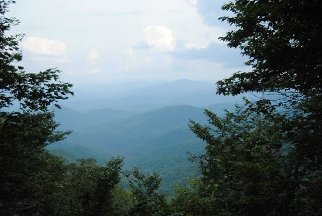
The trail is right gorgeous and pretty similar to Naked Ground in terms of difficulty. The beginning sections mix slight grades with moderate pulls. And closer to the summit (relatively) the tougher sections beat your quads. But oh, is it worth it. We turned right at the summit to head toward the Hangover and find a place to camp. We drop our packs and Liz and Amber go on to check for other sites. That last thing I hear from them is, "OH WOW!" and mumbled excitement. They had found the Hangover.

Never have I been so rewarded for working so hard. As the sun set behind the ranges, the shadows in the valleys grew. You could see it all. Stunning.

Being that it was 8 or later we needed to set up camp and cook dinner. Amber won camp chef for this trip as she brought hobo meals and eggs that all smelled delicious. We hung the bear bags and extinguished the fire. Once situated in our tents I noticed something haunting. SILENCE. Absolute stillness all around us. No wind. No bugs. No critters. It was eery. Of course I didn't sleep well. A few times I had dreams a bear was attacking us. Those sucked. But dawn came and 4 humans and 3 dogs emerged from tents unscathed.

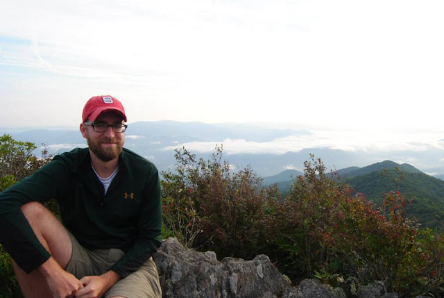
Sunrise at Hangover is a must. So we trundled out and I had a morning brewskie. Liz sipped on her wine. A nice way to start the day. Liz goes off to pick blackberies we saw the day before down the trail. She comes back with teeny, delicious berries and a bumble bee sting for her efforts. Breakfast was made and then we all went back to the Hangover to just sit and watch the clouds roll over the valley below us.

Sunrise at Hangover
Around noon we decided it was time to pack up and head to Naked Ground. We met a guy headed the opposite way and told him he should camp where we had the night before. Fifty minutes after leaving the Hangover we arrive in a familiar flat spot...

"OH! This is Naked Ground!" It was almost unrecognizable with all the greenery. We set up camp and ate some snacks. Then decided to head to Bob Stratton Bald.
View from campsite at Naked Ground - lots more foliage this time!
It wouldn't be a proper backpacking trip if we didn't take a wrong turn. At the junction we went right. We should have gone left. The bumble bees are out enjoying their day when 4 humans and 3 dogs come crashing their party. Liz is stung 3 more times near her tookus. And, for the first time in his outdoorsy life, Blake is stung by a bumble bee. Everyone rejoiced for him as he is now able to be tested to see if he is allergic. HOORAY?

It's a little hot, and with the growing number of angry bumble bees we're all done with hiking. We get back to camp and laze about the rest of the afternoon. It was glorious! This is the kinda backpacking I think I'm REALLY into. Hike in and then laze about for a few days. Blake goes to bed early, but the ladies stay up and chat about what I imagine most women chat about: farts, drinking, and dudes. At least the women I like to hang out with.

As in the first time we stayed in Naked Ground, this night greets us with howling wind that rolls up the mountainside. But being as tired as I am, sleep comes quickly and easily. I wake up feeling more refreshed and craving pizza and beer.
More Hangover!
We pack up and head back down Haoe Lead Trail. We reached the Jenkins Meadow Trail junction and start our descent. We appreciate the new signage the volunteer group has spent hours and hours installing. We're feeling pretty good and the trail is nice. A few times we question which trail is the actual trail, but the detailed guidebook never fails us. This trail gets a little hairy at times. Not in the "I'm going to fall off this mountain," kind. But the rhodo-hell kind. A classic Class I Rhodo-hell lasts for what seems like miles. We'd pop in and out of the rhodo-hell, but it's still tough going for most of the time.

There's also tons of poop on the trail. Tons. Liz frequently calls back, "Briers on the left! Poop on the right! Poop on the left! Briers....everywhere!"

After a few hours of hiking and poo dodging we begin to hear the rushing sound of water. We're all a little giddy because it means we can de-pack and rinse off. AND get our beers we've left in the car. Once we reach Amber's truck we pack into the bed and head up to get my car. We get back down to the stream and have the most glorious stream rinse off I've ever had. The beers were ok...kinda warm...but still a nice reward! Amber needs to get back early, but the rest of us are so intent on beer and pizza in Asheville we decide to part ways soon after our dip.
Mission Accomplished!
And thus ends a very successful 3 day, 2 night trip into the Joyce Kilmer wilderness. We've figured out the best combo of hiking trails and have some favorite hiking spots. And we know which trail never to take ever again. Our next NC adventure will hopefully be this fall in a new location. But Joyce Kilmer will be a special place that I'll always be willing to return to.
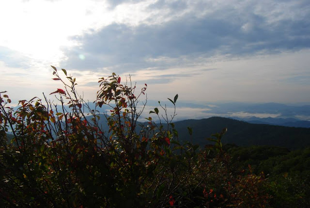
One last Hangover sunrise

Sunday, September 6, 2015

Joyce Kilmer Trip Breakdown and Photos

Trails covered
  1. Joyce Kilmer National Recreation Trail - 1.2 miles (lower loop), 0.8 miles (upper loop)
    1. Start elevation: 2,240 ft
    2. Highest elevation: 2,640 ft
    3. Why: Mature old growth forest with beautiful trees, easy walking 
    4. Pro tip: The big mamma jammas are at the far end of the trail on the upper loop. Make sure to locate the Naked Ground trailhead next to the bridge over Santeetlah if you're headed up there after taking the loop.
  2. Naked Ground Trail - 4.5 miles
    1. Start elevation: 2,300 ft (in the memorial forest)
    2. End elevation: 4,860 ft (at Naked Ground Gap)
    3. Why: Relatively well maintained, easy beginning section, but switchbacks near the gap are steep, Gold Star campsite at Naked Ground, gorgeous wildflower display in spring
    4. Pro tip: Hit the trail early to score the best campsite.
  3. Slickrock Creek Trail (to Big Fat Gap intersection) - 5.3 miles
    1. Start elevation: 2,010 ft (at Big Fat Gap trail intersection)
    2. End elevation: 4,860 ft (at Naked Ground Gap)
    3. Why: Great views over the valley and the chance to consider yourself a bad ass if you make it outta there.
    4. Pro tip: Just don't do this trail unless you are a masochist. For real. 535 feet every mile of ascent or descent. That's insane.
  4. Big Fat Gap Trail - 1.5 miles
    1. Start elevation: 3,060 ft (at trailhead)
    2. End elevation: 2,010 ft (at Slickrock Creek)
    3. Why: The fastest way to get to Slickrock Creek! It's also a pretty wide trail that provides for easy walking going down.
    4. Pro tip: If leaving out this trail plan for extra time to account for steepness. That's over 1,000 feet of elevation in just 1.5 short miles.

Masi ready for Day 2
Lego and Masi chill out in a scenic mountain stream while we take a break to rinse ourselves


BLUETS!

The view from my tent window at Naked Ground

Traveling companions headed up Naked Ground Trail


Potential Christmas card photo!

A happy dog

Another happy dog!

Trilliums everywhere!
Liz takes a break before we reach Naked Ground

Gorgeous scenery takes our minds off Slickrock Creek Trail's ball bustingness


Wild iris

My backpacking pals

The morning view of the Slickrock Creek valley is breath taking

Liz shoulders her giant pack full of rain soaked gear on Day 2

Massive snails abound along the trail

I did the thing

A sea of trilliums

It was a little chilly on night 1. Snuggles helped.


World's Edge - No , Really

Sometimes my work takes me to some interesting places. It ranges from the side of the interstate watching cars whiz by at 80 MPH to pastoral...